
|
|
||||||||||||||||||


| 2026-2027 Electoral Calendar, latest official version |

|
 |
|
|
|
|
|
|
|||||||
|
|
Haiti - Politic : Towards better access to data from the National Geospatial Center 29/07/2019 10:12:19
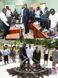
Jean-Claudy Pierre, Minister of Planning and External Cooperation, visited the National Center for Geo-Spatial Information (CNIGS) on July 24th. During this visit he met with Boby Emmanuel Piard, the Director General of the Center, about the day-to-day running of the CNIGS, current projects as well as the difficulties facing the Center. Minister Pierre suggested to the Center to carry out activities that could allow a greater popularization of the data produced by the CNIGS so that they are better known and accessible to all sectors of national life, especially to students. He also expressed the wish that the CNIGS extend its field of expertise to the marine and air cartography of Haiti. For his part, Piard stressed the need to develop closer relations with the technical directorates of the Ministry and other State entities to improve the quality of services provided to the population. Learn more about the CNIGS : Created by decree of March 27, 2005, the National Center for Geo-Spatial Information (CNIGS) is placed under the supervision of the Ministry of Planning which holds the chairmanship of the Board of Directors. The Center's mission is to produce and disseminate updated and reliable geographic information throughout the country through the use of appropriate modern technologies (including the use of satellites) to support planning, development decisions and actions of Haiti. See also : https://www.haitilibre.com/en/news-24444-haiti-technology-the-country-to-the-space-time.html HL/ HaitiLibre
|
|









|
|
Why HaitiLibre ? |
Contact us |
Français
Copyright © 2010 - 2026 Haitilibre.com |