
|
|
||||||||||||||||||


| 2026-2027 Electoral Calendar, latest official version |

|
 |
|
|
|
|
|
|
|||||||
|
|
Haiti - Irene : Threat on the North of Haiti 22/08/2011 08:40:50
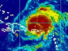
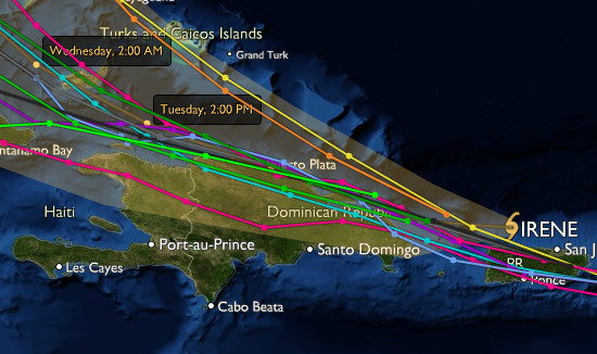
After hitting Puerto Rico, Irene became a hurricane category 1. Its current trajectory threatens the north of the Dominican Republic and Haiti, the Southern Region should be spared. To 6am, this Mondat, the center of Irene was located to 18.8 degrees north and 66.8 degrees West. To 583 km (363 miles) east of Port au Prince with sustained winds (maximum) of 120 km/h (75 mi/h), with higher gusts, ome strengthening is forecast during the next 48 hours. Winds extend outward up to 30 km (15 mi) from the center. Tropical-storm-force winds extend outward up to 240 km (150 mi), mainly northwest and northeast of the center. Irene is currently moving at 22 km/h (14 mph) along a trajectory West West-Northwest. This motion is expected to continue for the next couple of days. It will approach the Dominican coasts this afternoon or tonight, and should begin to affect Haiti by tomorrow 2pm. Following the current trajectory, Irene is located at: 425 km (264 mi) of Puerto Plata 583 km (363 mi) of Cap Haïtien 578 km (359 mi) of Port-au-Prince 624 km (388 mi) of Gonaïves 636 km (395 mi) of Saint-Louis-du-Nord 648 km (402 mi) of Port-de-Paix
Consequently, the level of vigilance red is maintained throughout Haiti (ie risk of impact of intensity violently to extreme) against the persistent threats of heavy rain, strong gusts of wind, with risks of rockfalls, landslide and flood, especially for the departments of the Northeast, North, Northwest, South, Southeast, Grand-Anse, Nippes, West, Centre and the Artibonite. The National Meteorology Centre in conjunction with the Maritime and Navigation Service of Haiti (SEMANAH) prohibits cabotage operations throughout the north coast of Haiti until further notice. This measure of restriction could be extended on the south coast and the Gulf of Gonave depending on the tendency of the system.
HL/ HaitiLibre
|
|









|
|
Why HaitiLibre ? |
Contact us |
Français
Copyright © 2010 - 2026 Haitilibre.com |